Morecambe Bay tunnel '“ your questions answered


WHAT IS BEING PLANNED? The biggest nuclear power station in Europe at Moorside near Sellafield in Cumbria.
WHY IS IT NEEDED?
The station will provide energy vital for keeping our lights on. Its delivery will also secure many thousands of jobs and billions of pounds of investment in the area.
WHY DOES IT AFFECT HEYSHAM?
Advertisement
Hide AdAdvertisement
Hide AdWHO IS BEHIND THE PROJECT?
Nu-Generation Ltd (Nu-Gen), a partnership between Toshiba in Japan and French company ENGIE, is proposing to build the power station. The electricity connections would be built and managed by National Grid, which owns the electricity transmission system in England and Wales, and operates it across Great Britain
IS IT DEFINITELY HAPPENING?
Not definitely but it’s looking likely. Nu-Gen will make a final investment decision in 2018. If all goes to plan building work could start in 2019.
HOW MUCH WILL IT COST?
The entire project would cost £2.8bn. National Grid says £1.9 billion would be spent on measures all along the route to reduce its effects on the landscape, local communities and environment. The tunnel will cost £1.2m.
WHAT IS PROPOSED BETWEEN MORECAMBE BAY AND MIDDLETON?
Advertisement
Hide AdAdvertisement
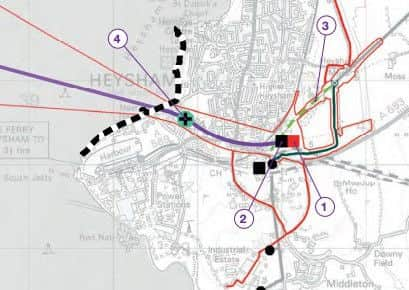
Hide AdNational Grid is proposing to build 13 miles of tunnel under Morecambe Bay carrying 400kV cables from Roosecote near Barrow-in-Furness to Middleton. They would also remove four 132kV pylon and build one cable end sealing pylon. They also want to extend the existing 400kV Middleton substation east of Heysham to include a tunnel head house.
WHAT IS A TUNNEL HEAD HOUSE?
It is a building containing fans to ventilate the tunnel and keep the electric cables cool. It would also provide access to the tunnel so site staff could carry out maintenance. A suspended monorail may go inside the tunnel to quickly transport site staff to areas that require maintenance.
WHAT SIZE IS THE TUNNEL HOUSE?
The tunnel house will be no larger than 55m long by 30m wide by 15m high. Designs are still being worked on.
WHY GO UNDER THE BAY?
A tunnel under Morecambe Bay avoids building a 60km (37.5 miles) connection onshore around the bay, through the South Lakes and into Lancashire. Of this, approximately 23km (14 miles) of the connection could have been in the Lake District National Park. This would also have affected Arnside and Silverdale and the Forest of Bowland Areas of Natural Beauty.
WHERE WILL THE TUNNEL GO?
Advertisement
Hide AdAdvertisement
Hide AdThe proposed route of the tunnel curves where it comes under land at Middleton to minimise the number of buildings and properties that it goes underneath. It is, however, believed it will go directly under six residential properties and five park homes in south Heysham before emerging in the tunnel head house at Middleton.
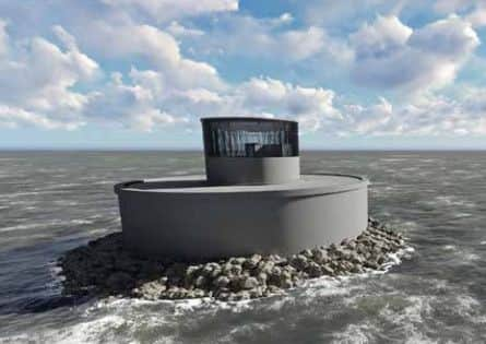
WILL ANYTHING BE VISIBLE IN MORECAMBE BAY?
An island would be built in the Bay to provide ventilation and emergency access to the tunnel. It would be 7.5km (4.7 miles) from Half Moon Bay. It would stand approximately 20m above sea level at high tide and around 30m above sea level at low tide. National Grid says it is unlikely to be visible from the shore.
COULD IT BE USED AS A ROAD TUNNEL?
The tunnel would not be suitable for road traffic, emergency vehicles or pedestrians. It could only be used to carry electricity transmission cables, as per the obligations of National Grid’s licence. It would also be too small for vehicles to use.
HOW FAR UNDERGROUND WOULD THE TUNNEL GO?
Hi-tec tunnel boring machines would be used to drill between 30m and 60m below the seabed and ground.
ANYTHING ELSE HAPPENING?
Advertisement
Hide AdAdvertisement
Hide AdTrees would be planted to the north-west and east of the extended 400kV substation to help screen views of it. National Grid may also build a temporary tunnel inspection shaft near Penrod Way to allow inspection of the tunnel boring machine and potentially replace its cutting face before it goes under the bay. This tunnel shaft may not be needed; the decision will be made once a tunnelling contractor is appointed. The shaft would be filled in afterwards and the land restored to its previous state. Studies have shown that the geology under the Heysham side of the bay would be very hard to cut through, which is why this shaft may be required.
HOW CAN I GIVE MY VIEWS ON THIS?
A public consultation is open until January 6 2017. For more details see HERE.
See HERE for videos of the planned construction.
See our story on what Heysham residents think HERE